September 24, 2026Patagonia · Chile & Argentina2 min read
16,000 square kilometres of ice, and a border nobody has drawn
The Southern Patagonian Ice Field is one of the largest bodies of ice outside the poles, a factory of glaciers — and home to the last unfinished stretch of the Chile–Argentina border.
The short version
- The Southern Patagonian Ice Field covers roughly 16,500 km² — about 14,200 in Chile and 2,600 in Argentina — and runs some 350 km north to south.
- Outside Antarctica and Greenland, only the ice fields straddling Alaska and Yukon are larger by contiguous area. You will often read “third-largest ice on Earth”; how you count decides the rank.
- It feeds dozens of glaciers, including Pío XI, the largest in the Southern Hemisphere outside Antarctica. One stretch of border across it has still not been demarcated.
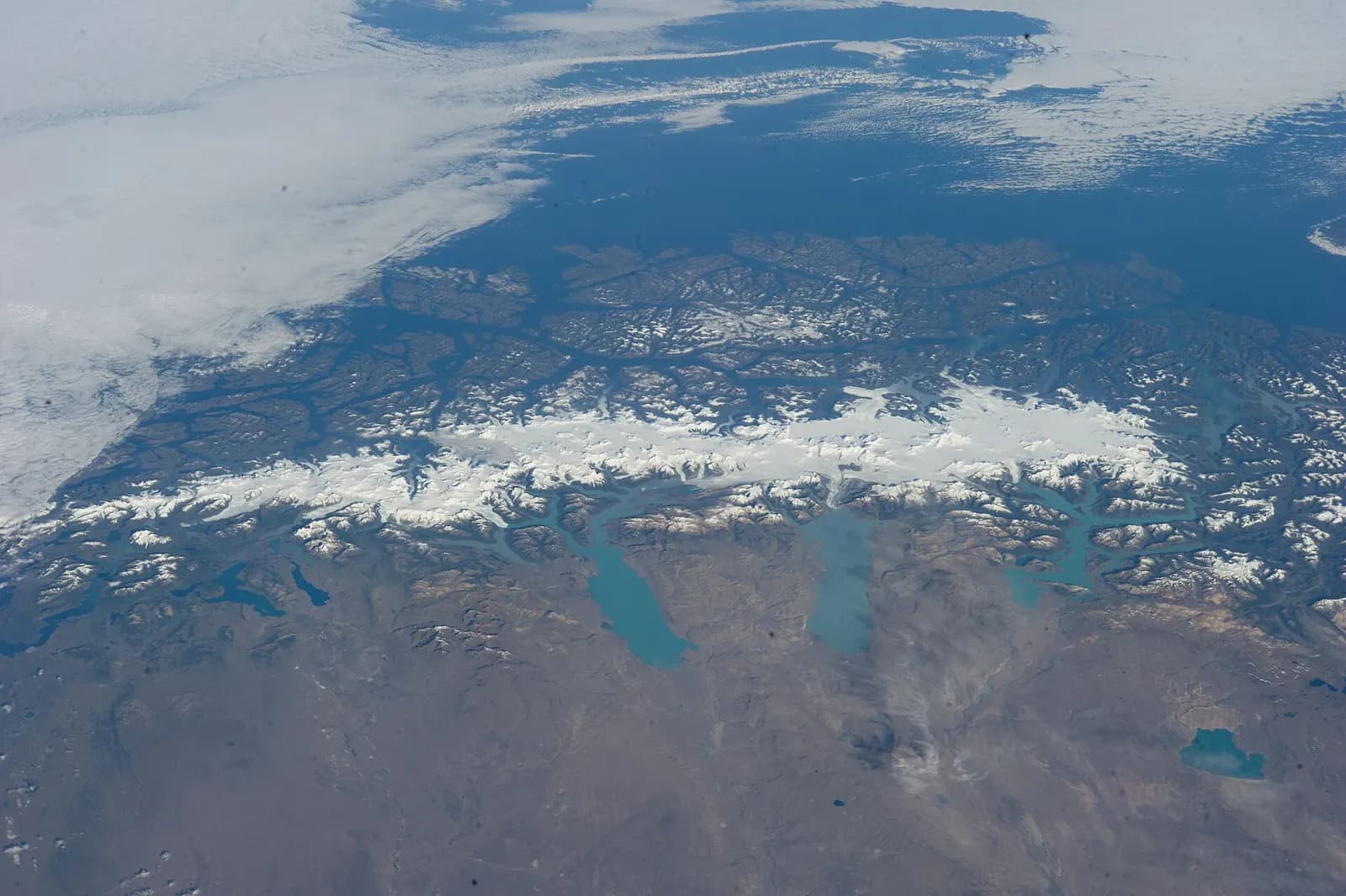
From the International Space Station it looks like a scar of white along the bottom of the Americas. On one of the rare clear days, an Expedition 38 crew member photographed it end to end: a continuous band of ice riding the spine of the Andes, with turquoise glacial lakes pooled along its eastern edge.
This is the Hielo Patagónico Sur, the Southern Patagonian Ice Field. It covers roughly 16,500 square kilometres — about 14,200 in Chile and 2,600 in Argentina — and stretches around 350 kilometres between latitudes 48°15′ and 51°30′ south.
How big is “big”?
You will often see it called the third-largest expanse of ice on Earth, after Antarctica and Greenland. That depends on how you count. Measured as a single contiguous ice field outside the polar ice sheets, it ranks second, behind the linked ice fields of the Saint Elias Mountains on the Alaska–Yukon border. Either way, it is the kind of place where the unit of measurement stops being kilometres and becomes days.
A factory of glaciers
The ice field is less a place than a source. It feeds dozens of outlet glaciers that pour east into the lakes of Argentina and west into the Chilean fjords. The best known, Perito Moreno, draws the crowds. The biggest, Pío XI, covers about 1,265 km², making it the largest glacier in the Southern Hemisphere outside Antarctica.
The border no one has drawn
The ice has also resisted cartographers. Chile and Argentina signed an agreement in 1998 to settle the line from Monte Fitz Roy to Cerro Daudet, but one section — from Fitz Roy to Cerro Murallón — was left until a detailed 1:50,000 map could be made. It is still the last boundary section between the two countries that has not been concluded. A traveller up there can stand on ice whose country is, strictly speaking, pending.
Why the interior stays quiet
Crowds come to its edges, to the glacier fronts and the lakes. Crossing it is a different undertaking: a roped, self-supported glacier journey where, once a team is committed, there is no resupply and the weather is set by the Southern Ocean. That is exactly why the interior stays as quiet as it does.
Questions people ask
- How big is the Southern Patagonian Ice Field?
- Roughly 16,500 km², of which about 14,200 km² lie in Chile and 2,600 km² in Argentina. It stretches around 350 km from 48°15′ to 51°30′ south.
- Is the Southern Patagonian Ice Field the third-largest ice field in the world?
- It is often described that way, after Antarctica and Greenland. Measured as a contiguous ice field outside the polar ice sheets, it ranks second, behind the ice fields of the Saint Elias Mountains on the Alaska–Yukon border.
- Is the border between Chile and Argentina defined on the ice field?
- Not entirely. Under the 1998 agreement, the section from Monte Fitz Roy to Cerro Murallón awaits a detailed 1:50,000 map and is still the last boundary section between the two countries that has not been concluded.
Sources
Every factual claim in this dispatch comes from the sources below.
- Southern Patagonian Ice Field — Wikipedia
- Campo de hielo patagónico sur — Wikipedia (español)
- ISS-38 Southern Patagonian Ice Field (file description) — NASA via Wikimedia Commons